

The day before a storm system brought downpours and severe weather watches to Central Texas, Hays County residents had an opportunity to learn about flood safety from the National Weather
The District’s Water Conservation Period starts Wednesday, May 1st and extends through the end of September—the time when water use is at its peak. Recent wet weather has helped augment
UPDATE 9 PM:
It was a clean sweep at the Wimberley polls for the city council election with one group of candidates winning a decisive victory.
This story was originally published in May of 2016. It is shared here to help inform the public on the flood stages in Wimberley.
Knees went weak and blood pressures rose for miles downstream last Thursday after the gauge on the Blanco River at Wimberley reported a rapid 30-foot rise. And there was a huge sigh of relief after it became known the gauge had malfunctioned.
Thirty feet, after all, is within 15 feet of the catastrophic wall of water that moved down the Blanco on May 23/24 of 2015, killing a dozen people and knocking homes off their foundations before inundating San Marcos neighborhoods and business parks and depriving the city of both its Internet providers.
As all long-time residents of the area know, each flood is unique; however, the National Weather Service has put out some guidelines on flood impact that can put river rises in perspective.
For example, a six-foot rise in the Blanco, much like what occurred on Thursday, affects “low lying areas and crossings of secondary roads near” in and around Blanco, while a rise of 10 feet has implications for river recreation.
With a 10-foot rise, the NWS says, river conditions all the way from Blanco to below San Marcos become dangerous, “Low dams create hydraulic jumps which can trap canoeists and kayakers,” the NWS says.
Recreation is “very dangerous” all the way to the Blanco’s convergence with the San Marcos River including at John Knox Camp and near Five Mile Dam when the Blanco rises 21 feet. Motorists are also endangered on secondary roads and bridges, many of which are equipped with gates.
At 25 feet, the water is approaching some Wimberley homes. “Widespread lowland flooding can cut off low areas of the floodplain drowning livestock,” the NWS says. “Homes along Cypress Creek near Wimberley are threatened. As the Blanco River backs up Cypress Creek additional runoff down Cypress Creek can easily flood homes. Roads near the lower Blanco River in northeast San Marcos flood severely. Water approaches the lowest homes in that area. Livestock are cut off and potentially drowned.”
It just gets worse.
26 feet: “Major flooding impacts several lowest homes on the Blanco River near Wimberley. Homes along Cypress Creek near Wimberley also are threatened by the Blanco River backwater and any flow down Cypress Creek. Major flooding of the lower Blanco River in northeast San Marcos floods lowest homes and inundates roads and low bridges with several feet of water near the river making them extremely dangerous. Livestock are cut off and potentially drowned.”
29 feet: “Many lowest homes in the Blanco River flood plain near Wimberley flood. Lowest homes and businesses in the Cypress Creek flood plain flood by backwater from the Blanco River and any runoff down Cypress Creek. Lowland flooding downstream in the lower Blanco and San Marcos Rivers severely floods lowest homes, roads and bridges near San Marcos. Livestock in the Blanco River flood plain above Blanco to the San Marcos River confluence are cut off and potentially drowned.”
31 feet: “Disastrous life threatening flooding will flood over a hundred homes and businesses in and near Wimberley in the Blanco River and Cypress Creek flood plains. Many homes flood severely downstream in the lower Blanco and San Marcos River flood plains near San Marcos. This level will reach lower rural homes in the flood plain above Blanco to below San Marcos and can trap and drown hundreds of livestock. Roads near the river are extremely dangerous.”
38 feet: The highway 12 bridge becomes overtopped and is impassable. Disastrous life threatening flooding will flood hundreds of homes and businesses in and near Wimberley in the Blanco River and Cypress Creek flood plains. Many homes flood severely downstream in the lower Blanco and San Marcos River flood plains near San Marcos. This level will reach lower rural homes in the flood plain above Blanco to below San Marcos and can trap and drown hundreds of livestock. Roads near the river are extremely dangerous.”
The official height of the Memorial Weekend Flood was 44.9 feet.
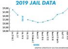
The cost of outsourcing Hays County inmates is still rising, according to the weekly report from the sheriff’s office. At the Hays County Commissioners Court meeting Tuesday, Hays County Judge


Who knew that Wimberley needed a walkabout? A jailbird (jailroo?) Australian marsupial took Wimberley, and Texas, on an adventure last week after the kangaroo escaped an exotic wildlife ranch near
Texas achieved an unemployment rate of 3.8 percent in March, but Hays County’s was a full point lower at 2.8 percent, Texas Workforce Commission figures indicate. The jobless rate last


 with Bizzy Campbell and Olivah Bladwin.")
 with their butterflies.")


The beauty of a butterfly can hardly be matched. That is, unless you have thousands of them released after being cared for by an entire community. “It was the most
Heart of Texas Genealogy Society meeting Heart of Texas Genealogy Society will meet on May 2, 2019 at the Wimberley Village Library. David Arscott will do apresentation on “ Medieval
Last week’s article on the Gifted and Talented class’s playground design misidentified the Scudder Elementary teacher. Her correct name is Jamie Chase. We apologize for the mistake.
Expansion of the Wimberley Village Library could be $10,000 closer to becoming a reality by the end of May thanks to a challenge grant from Ozona Bank. The bank is
The city of Woodcreek and Camp Young Judaea are co-sponsors of a community get-together on May 5 at the camp, which is in Woodcreek. All residents of Woodcreek and Woodcreek

WIMBERLEY MAYOR SUSAN JAGGERS Good morning Wimberley. There are less than 3,000 registered voters in the city of Wimberley. Less than fifty percent of those usually turn out to vote.
P.O. Box 49
Wimberley, TX 78676
Phone: 512-847-2202
Fax: 512-847-9054


