

A tornado touchdown a few miles south of Wimberley on Friday night.
According to National Weather Service Austin/San Antonio Meteorologist Matthew Brady, there was tornado with peak winds of 110 miles per hour that touched down in Kendall County and continued 20 miles into Comal County to the north of Canyon Lake.
While the tornado didn’t hit Wimberley directly, high winds caused damage across the area.
On Monday, the city of Wimberley alerted citizens to a Fire Weather Watch from the National Weather Service in Austin/San Antonio. In effect from Wednesday morning through the evening, the NWS said that a strong cold front will arrive Tuesday, resulting in gusty winds and low relative hu- midities on Wednesday and conditions will be favorable for critical fire danger across much of South Central Texas.
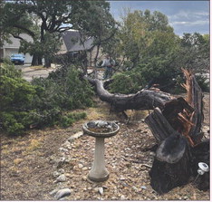
HIGH WINDS BROUGHT DOWN TREE LIMBS IN WOODCREEK ON BROOKMEADOW DRIVE. PHOTO BY JEFF RASCO
Affected areas include the Hill Country, Edwards Plateau, the I-35 Corridor and Coastal Plains. Winds from the Northwest at 15 to 25 miles per hour could include gusts up to 35 mph. Any fires that develop could rapidly increase in size and intensity, move quickly and be very difficult to control.
The Fire Weather Watch means that critical fire weather conditions are forecast to occur and that citizens should listen for later forecasts and possible Red Flag Warnings.


